Tasmania’s Snowy Range today … you’d think a fire was burning nearby
Aside from a fire in the north-east, there are no major fires in Tasmania, yet the Snowy Range in Tasmania’s south was covered in a distinct haze today.
This area should have some of cleanest air in the world.
Meanwhile, South Australia has broken November records … the Bureau of Meteorology said multiple areas broke their maximum November temperature records, including:
Hindmarsh Island 40.7C
Nullarbor 46.6C
Murray Bridge Airport 44.0C
Kingscote Airport 39.1C
Stenhouse Bay 40.1C
Robe Airfield 38.0C
Parafield 44.3C
Keith 44.3C
Padthaway South 39.9C
Clare 40.8C
Strathalbyn 43.1C
Lameroo 44.0C
Naracoorte 40.2C
Parndana 38.1C
Nuriootpa 42.1C
Large areas were 16C above the November average.
Perhaps Tassie is heading in this direction, come January/February. As I write this, 35C in the shade in the Huon.
Fire damage on the mainland so far. And it’s not yet December …
#NSWRFS Building Impact Assessment teams are continuing their inspection of fire affected communities. In the past fortnight, 421 homes have been destroyed. Around 2000 homes have been spared. Already this fire season, six lives have been lost and 530 homes destroyed.#nswfirespic.twitter.com/c4Hlon64DZ
A polar blast is spreading out over the mainland as I write this.
Whether it is related to the unusual stratospheric warming event I mentioned earlier this year I do not know, but we are having a very wet and cold November in southern Tasmania, after hitting 34C and humid just a few days ago.
The Snowy Range is well covered in white.
Meanwhile, north of the polar intrusion, unprecedented fires burn in NSW/SEQ (below) …
The top two images show the latest methane levels recorded at Barrow, in the Arctic.
The bottom image shows the record slow refreeze of ice in one of the Arctic seas.
Is something happening in the Arctic?
The methane spike has not yet been picked up at other global sites, but if Barrow is showing the beginning of a feedback loop fed by melting undersea methane hydrates, and thawing permafrost, we may be seeing the beginnings of a climate change feedback loop and an increase in the rate of global warming.
With Arctic towns relocating because of melting permafrost, and seals and seabirds turning up dead in the high latitudes, things are looking a bit odd in the northern hemisphere.
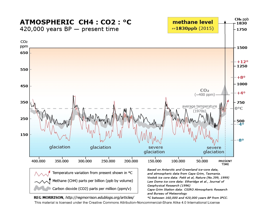
And below, some food for thought. The graphic is by Reg Morrison.
The road from from Huonville to Cygnet is already being cut off during floods, while the Huonville-to-Franklin route and Huonville-to-Judbury have low spots which will be a problem in future.
The report in the above link notes an acceleration in global warming, not unexpected given the vast increase in greenhouse gas output over the past 30 years.
Sea level rise will bring more flooding to Huonville. The Huon River floods quite regularly, and higher sea levels will worsen the effects.
Parts of some Huon roads will eventually go under during high tides.
Global warming and sea level rise will speed up further as Antarctic, Arctic and Greenland ice caps melt and the sea warms.
Heat to more than 70C above normal has been recorded in the stratosphere, and this will likely affect southern hemisphere weather soon.
Tasmania could cop severe cold blasts, while mainland Australia could be extremely dry this summer.
Blue Skies Weather forecaster Tony Trewinnard said: “Temperatures at 30km are in single digits and that’s 50, 60, 70C warmer than normal at that altitude. That is quite bizarre.
“We may find the spring season as a whole turns out cold, or summer is. It isn’t affecting our (NZ) weather patterns here yet, but basically it will only be a matter of time.”
Noll said the sudden stratospheric warming was a “climate driver”.
“It influences weather patterns over weeks to months but isn’t a predictor of day-to-day weather,” he said.
“It can and will influence patterns during October and, given the longevity of the event, it may be a player into November. So it’s not over yet.”